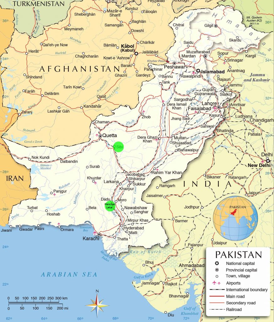
Sindh is the southern province of Pakistan. People around the world are more familiar with the place as the location of ancient Indus Valley Civilisation.
Indus river, which lends it’s name to India and Hinduism is locally known as Sindh river. Indus being it’s romanised name and Hind being persianised name. This river runs across Pakistan, collecting water from Afghanistan through Kabul river, from the Himalayas in the Pushtoon province of Khyber Pakhtunkhwa in the north, where they call it Seend or Seen, and finally from Kashmir and India through four more rivers in the Punjab (meaning Five Waters, referring to the five rivers Sindh, Jehlum, Chenab, Ravi, and Sutlej) in the middle, and then continuing as river Sindh through the province of Sindh. During monsoon, Sindh province also gets water from the western province of Baluchistan, which first fills some lakes in the Sindh province, and then spills into the river Sindh.
On both sides of the river, there are flood plains that get inundated almost every year during the monsoon season. This area is called Kutcho, which means impermanent in Sindhi language. When the river flow is low, people cultivate these lands which are very fertile. At the edge of these lands, there are embankments on both sides of the river which stop flood waters from spreading further out where the permanent settlements are.
Occasionally, the monsoon waters from Baluchistan arrive at the same time in high volumes when the river Sindh itself is running at full capacity. If these waters are more than the capacity of the lakes on the way and the river isn’t accepting any overflow from these lakes then the lake water spills over the embankments, other barriers get breached and the north western part of Sindh province gets flooded to some extent.
In 2022, it rained continuously for over a month with extremely high intensity over the province of Sindh. In some places it rained as much as 1500mm in a single day. This caused flooding and the land got completely saturated. Baluchistan suffered similarly, and the water from there formed a huge water body that ran from Sibi in Baluchistan (marked with green dot on map) to Manchar Lake in Sindh (marked by another green dot on the map below). This was compounded by a massive flood in river Sindh at the same time, which meant none of the excess water from the lakes could be drained into the river. Eventually many embankments and barriers were breached, highways and bridges swept away and the north western Sindh got flooded to an unprecedented extent in recent history. Flood from the rains and river also hit other parts of Sindh, as well as the other three provinces of Pakistan.
The distance from Sibi to Manchar Lake is about 220 miles. For perspective, imagine the land between Lake District and London in England becoming a huge lake.
On the right, the deep blue is the flood water that covers many cities, towns, and villages. Most of the people have evacuated from these flooded areas, however many are still stuck in far flung areas which are only reachable by boats at this time. Some people have willfully stayed behind to protect their properties. Many people including children, as well cattle have drowned. It is simply not possible to tell the numbers regarding loss of life at this time, whatever numbers are being presented in media are guesstimates that are likely to be wrong. Buildings in many villages have been completely destroyed. Standing crops have been swept away, and the farmers haven’t been able to sow for the current season. It’s becoming increasingly likely that the Sindh province will be hit by a famine as well.
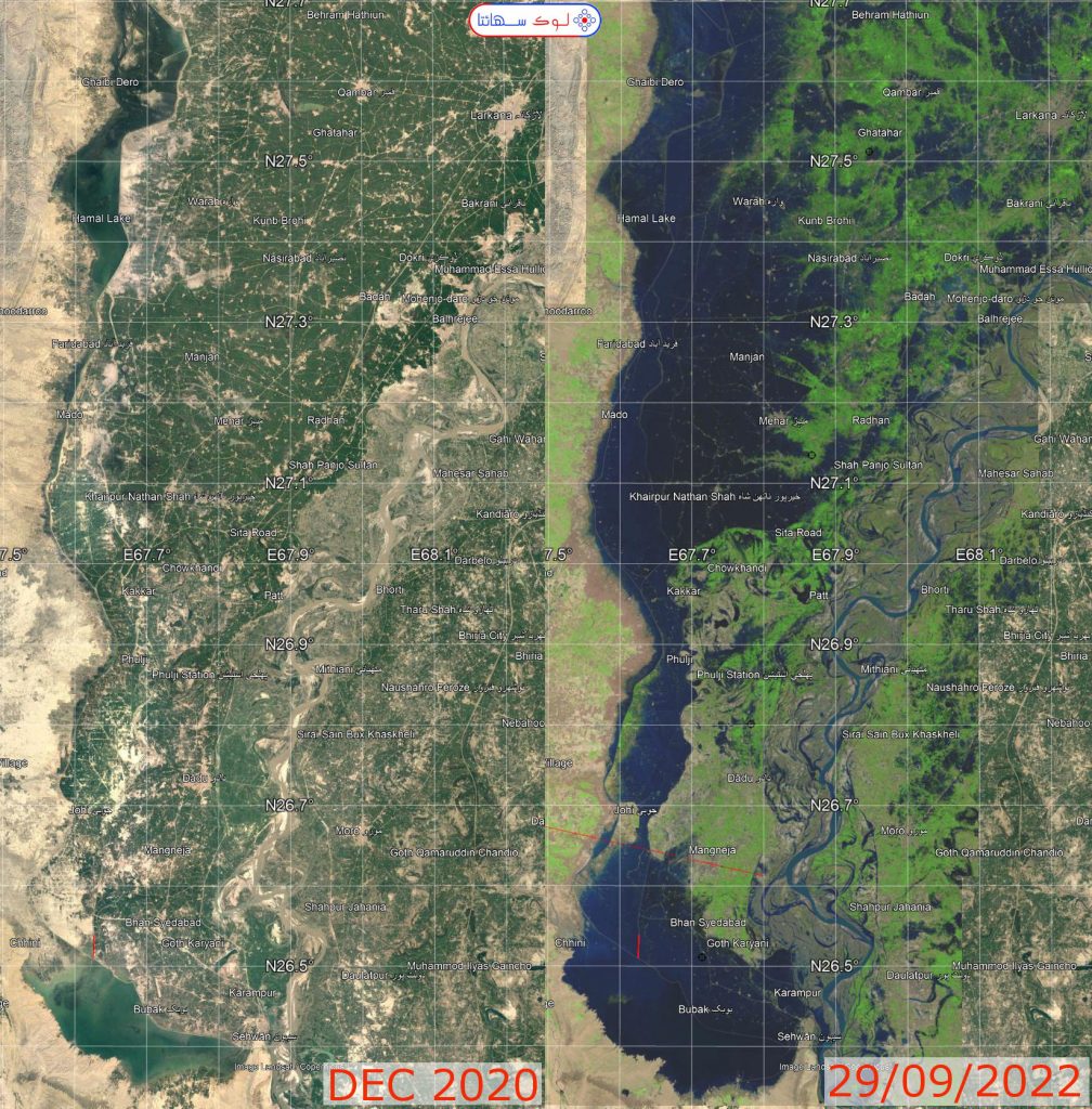
Above is a compilation of satellite views of the northern side of Manchar Lake from 2013 to the floods in 2022. It is just a small part, zoomed in on part of the lake and adjacent lands. All the green dots or small rectangles that appear are agricultural fields. Runway of Sewhan Airport is also visible to the north eastern side of the lake.
Displaced People
According to some early estimates by the government, approximately 33 million people have been affected by the flood, many of which have been displaced due to deep water in many areas. These numbers are likely to have risen since flood has spread further now.
People have been affected differently, depending on several factors. Majority of those who were relatively well off have either moved to their relatives in other cities which aren’t affect as bad, or they have rented places in such cities. Ethnic Sindhi people traditionally don’t wander away from their hometowns and villages, whatever the circumstances. They have moved to the nearest highways or embankments that have survived, and have stayed their, hoping to return to their homes soon. Ethnic Balochi people are from barren hilly areas of Balochistan, and they are used to move around wherever they find resources to feed their animals. Many of them are now settled in Sindh and involved in agriculture, but they don’t have the high resistance to moving around like Sindhi people. Some people didn’t believe the authorities when told to evacuate, and have become stranded on small islands surrounded by flood water.
Those willing to move away from their villages in order to escape from the flooded areas have headed towards the higher grounds in hilly areas. A large number of such people have camped in Tanboo Goth (Tent Village) in Jamshoro.
Tanboo Goth is currently the largest and well organised tent camp in Sindh, managed by Lok Sahaita in coordination with Sindh Police and Divisional Administration.
More details about the Tanboo Goth are here.
![]()